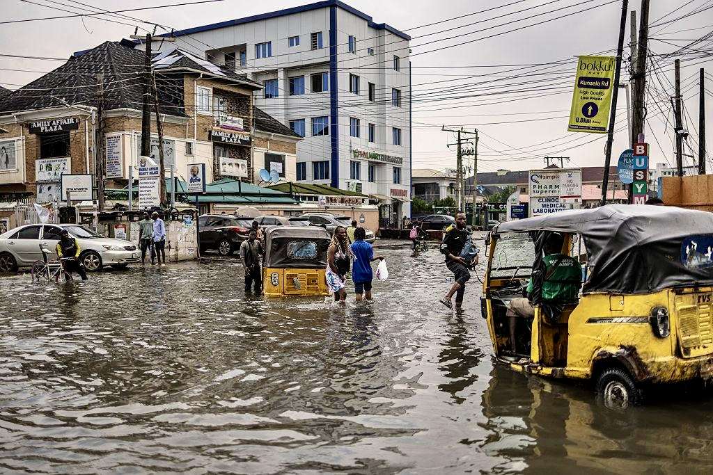
Lagos has issued one of its clearest flood warnings of the year. But the order to move exposes a harder urban question: how does a coastal megacity protect people when the places vulnerable to water are also where homes, businesses and livelihoods have taken root?
Lagos is telling residents in its most vulnerable communities to move before the water arrives.
That instruction sounds simple. For a family living beside a lagoon, river, wetland, drainage channel or waterfront, it may be anything but.
On Monday, the Lagos State Government directed people living in low-lying and flood-prone communities to relocate temporarily to higher ground after the Nigeria Hydrological Services Agency (NiHSA) issued a seven-day high riverine flood-risk warning covering Lagos and 14 other states.
The warning period runs from September 19 to September 25, 2026, putting the state inside an active risk window now. NiHSA says rising river levels could trigger flooding in vulnerable communities and affect schools, healthcare facilities, markets, farms and places of worship.
The Lagos government has specifically identified Eti-Osa, Lagos Island, Oke-Ira Nla in Ajah, Kirikiri, Ilaje Waterfront Jetty and Jetty Terminal B among vulnerable locations.
It has also placed communities including Isheri North, Kara, Itowolo, Ajegunle, Majidun, Ogolonto and parts of Agboyi, as well as settlements downstream of Isheri Olofin, on heightened alert.
Commissioner for the Environment and Water Resources Tokunbo Wahab urged residents not to wait until floodwaters rise.
“When the signs point to danger, the safest decision is to move early. No property is worth risking a life.”
It is the right message for an emergency.
But beneath the evacuation order lies a much bigger question for Lagos: what happens when the safest place is increasingly somewhere people cannot afford to live?
The Water Does Not Have to Start in Lagos
One of the most important details in the warning is easy to overlook.
Lagos is not only being warned about rainfall falling directly over the city.
Wahab specifically drew attention to the Ogun River and other major waterways, warning that heavy rainfall and rising water levels upstream could affect downstream communities in Lagos.
That means a flood emergency can develop through a chain of events extending beyond the neighbourhood where people eventually see the water.
Rain falls upstream.
River levels rise.
Water moves through connected systems.
Low-lying settlements downstream become exposed.
By the time residents see water entering streets and compounds, much of the hydrological process may already be well advanced.
NiHSA Director-General Arch Umar Mohammed described the national situation in similar terms, saying: “Rising river stages are expected to cause flooding. Communities on the floodplain should prepare to move to higher ground.”
For Lagos, that makes early warning more than a public-information exercise.
It is a race against the speed at which water can move.
Lagos Has a Flood Problem Older Than This Week’s Forecast
The latest warning is not an isolated weather event.
A 2026 World Bank assessment of Nigeria’s flood and drought risk says rapid and uncontrolled urbanisation, development in flood-prone areas, poor drainage and blocked waterways are intensifying flood risks in major cities including Lagos.
The assessment also identifies coastal flooding, sea-level rise, wetland encroachment and inadequate coastal management as interconnected risks.
That distinction matters.
It is tempting to explain every Lagos flood through one familiar cause: heavy rainfall.
Rainfall clearly matters.
So do blocked drains and indiscriminate dumping, which the Lagos government again warned residents against this week. Blocked drainage channels can restrict the movement of stormwater and prolong flooding.
But the wider evidence points to a more complicated urban equation.
Lagos is a low-lying coastal city. Parts of the metropolis sit close to sea level. Urban growth has transformed land surfaces that once absorbed or temporarily stored water. Wetlands and other natural systems that can help manage excess water have come under pressure from development.
The World Bank’s latest national flood assessment says wetland encroachment and loss of natural coastal barriers can weaken resilience to sea-level rise and storm surges.
The implication is uncomfortable.
A drainage problem can be engineered. A changing landscape is harder to reverse.
A New Scientific Warning Is Even More Troubling
Recent research suggests Lagos’s future flood exposure is not determined by rising seas alone.
A peer-reviewed study published in npj Natural Hazards in August 2026 examined the combined effects of sea-level rise and vertical land movement in Lagos using satellite radar measurements from 2015 to 2025.
The researchers found local vertical land-motion rates ranging from -11.40 to +0.76 millimetres per year, meaning some areas are subsiding while others are comparatively stable or rising.
The study found that subsidence can substantially increase projected flooding compared with calculations based on sea-level rise alone. In some densely populated parts of Lagos, it increased projected inundation dramatically and advanced projected flooding timelines by decades.
That finding changes the meaning of the current evacuation warning.
The issue is not simply whether Lagos receives enough rain this week.
The deeper issue is whether parts of the city are physically becoming less capable of keeping water out or moving it away.
The Real Test Begins After the Alert
Issuing an evacuation warning is one thing.
Making evacuation possible is another.
For a household in a flood-prone settlement, leaving can mean abandoning a house, shop, fishing equipment, livestock, stock in a small business or belongings accumulated over decades.
For traders, a flood warning may also carry an economic calculation.
Move too early and income can disappear.
Move too late and the cost can become catastrophic.
That is why the effectiveness of a flood warning cannot be measured only by whether a government issues it.
It must also be measured by whether people receive the information in time, understand what it means, trust it and have a realistic place to go.
Nigeria’s 2026 World Bank flood-risk assessment itself calls for stronger early-warning systems, better flood mapping, improved communication and integrated flood-risk planning combining drainage and other physical measures with land-use regulation, public awareness and evacuation strategies.
In other words, an evacuation order is the final link in a much longer chain.
If the chain breaks anywhere, people may still be in danger.
Where Are the Safe Places?
The most difficult question raised by Lagos’s latest directive may therefore be the least discussed.
Where exactly should displaced residents go?
The state government has instructed vulnerable residents to move to safer locations and has called on local governments, emergency agencies and community leaders to activate early-warning and response mechanisms.
But temporary relocation is not simply a matter of telling people to find higher ground.
Families need somewhere secure to stay.
Children need access to schools.
People with disabilities and older residents may require assistance.
Livestock must be moved.
Businesses need protection from avoidable losses.
Essential documents, medicine, food and drinking water may need to be secured.
The longer flooding persists, the more these demands become humanitarian rather than purely environmental.
That is why the current warning should be viewed not only as a forecast but as a test of Lagos’s emergency-readiness architecture.
The City Cannot Evacuate Its Way Out of the Problem
Temporary relocation can save lives.
It cannot, by itself, solve recurring flood risk.
The World Bank’s 2026 assessment calls for a combination of infrastructure investment, floodplain management, improved land-use regulation, stronger early-warning systems, better drainage, nature-based solutions and more coordinated institutions.
That is particularly relevant to Lagos, where the geography creates a difficult combination of coastal exposure, waterways, dense development and intense economic activity.
There is also a basic urban-planning question that becomes more urgent every rainy season:
Should people continue to build homes and businesses in places where governments repeatedly have to order them to leave?
The answer cannot be reduced to blaming residents.
People live where they can find affordable housing.
Businesses operate where customers are.
Informal settlements frequently emerge where land is available.
Waterfront communities often have long-established livelihoods tied to fishing, transport and commerce.
Yet the longer development continues in areas known to be highly exposed, the more expensive future protection becomes.
Lagos Has One Advantage: The Warning Came Early
The state’s current response does contain an important strength.
Officials have acted before a major flood disaster has been confirmed during the current alert window.
The government says it is intensifying monitoring of river levels, rainfall patterns and vulnerable communities, while continuing drainage maintenance and working with federal agencies.
That creates a window for prevention.
The challenge is whether that window is used effectively.
A useful measure over the coming days will be what happens in the communities that have been named.
Do residents actually move?
Are vulnerable households reached beyond social-media announcements?
Are safe temporary locations clearly identified?
Are emergency agencies visible on the ground?
Do local leaders have the information and resources needed to organise early movement?
Are roads and evacuation routes kept accessible?
And when the water recedes, what happens to the people who cannot safely return?
Those are the questions that will determine whether this warning was merely another public advisory or an example of effective disaster prevention.
One Reporting Detail Needs Clarification
There is also a numbering discrepancy worth flagging.
The Lagos directive, as reported by Channels Television and several other outlets, refers to the advisory as NFA-2026-2022.
But Punch, the International Centre for Investigative Reporting and several reports on the original NiHSA warning identify the seven-day advisory as NFA-2026-262.
The substantive details — the September 19–25 warning period and 15 affected states including Lagos — are consistent across the reporting reviewed.
The discrepancy in the advisory number should nonetheless be clarified by NiHSA or the Lagos government, particularly because flood warnings are operational documents and precision matters during emergencies.
The Bigger Warning
Lagos has been told to move people away from water.
That is necessary.
But the longer-term warning is about something larger than this week’s rain.
Recent research is showing that the city’s flood exposure is shaped by river levels, rainfall, tides, drainage, land use, wetland loss, coastal processes and land subsidence rather than a single cause.
That means Lagos cannot depend indefinitely on a cycle of rainfall, warning, flooding, evacuation, clean-up and return.
Every emergency creates another bill.
Every damaged home creates another displaced family.
Every flooded business loses stock and income.
Every school or health facility forced to close weakens the city’s ability to function when residents need services most.
The most important question raised by this week’s directive is therefore not whether residents should take the warning seriously.
They should.
The more difficult question is whether Lagos can move from responding to people trapped by flood risk to redesigning the city so fewer people are trapped by it in the first place.
For now, the immediate message remains brutally simple.
When the warning comes, move early.
And when the water goes down, the harder work must begin.
Follow us on our broadcast channels today!
- WhatsApp: https://whatsapp.com/channel/0029VawZ8TbDDmFT1a1Syg46
- Telegram: https://t.me/atlanticpostchannel
- Facebook: https://www.messenger.com/channel/atlanticpostng